

Redistricting portions of 25321 and 25331 Township Road 544
Consultation has concluded
Invistec Consulting Inc., on behalf of Landrex Hunter Ridge Inc., applied to amend the Land Use Bylaw 18/2024, Schedule A, by redistricting portions of 25331 Township Road 544 and 25321 Township Road 544.
Location
The redistricting is located in the northwest portion of the Northeast St. Albert Area Structure Plan (ASP). The legal description, Alberta Township System (ATS) reference, and municipal addresses are shown in Table 1. The ATS is a land survey system used in Alberta to identify specific parcels of land based on section, township, range, and meridian. This reference helps accurately locate properties within legal land descriptions. More information on the ATS system can be found here: Alberta Township System Explained (Government of Alberta).
Table 1: Legal Description, ATS Reference, and Address
Legal Description | ATS Reference | Address |
A portion of Plan 052 0323, Block 1, Lot 1 | NW ¼, Section 21, Township 54, Range 25, West of the 4th Meridian | A portion of 25331 Township Road 544 |
A portion of Plan 062 5326, Block 1, Lot 2 | NW ¼, Section 21, Township 54, Range 25, West of the 4th Meridian | A portion of 25321 Township Road 544 |
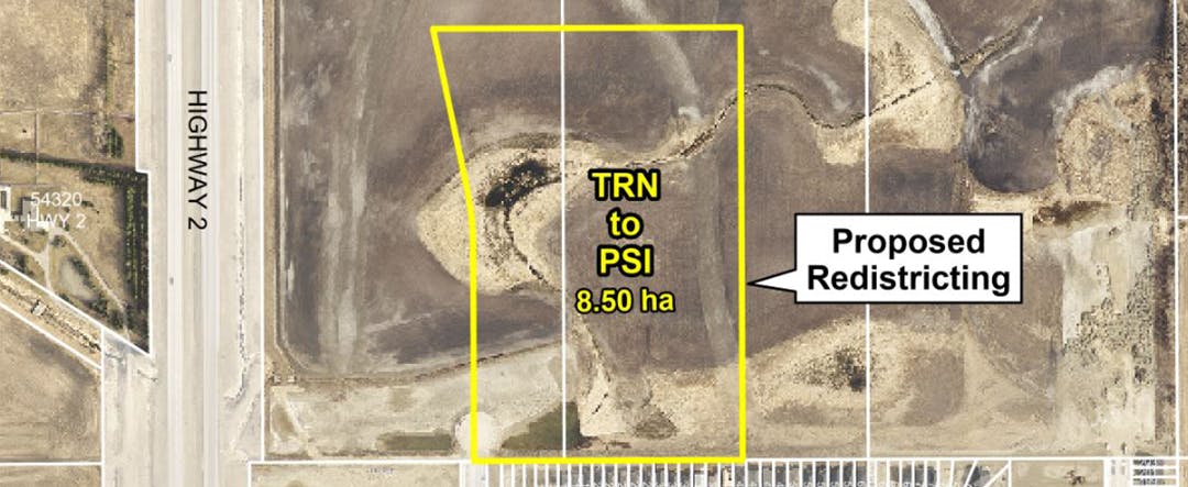
Proposed Land Use Bylaw Amendment (Redistricting)
Redistricting refers to changing the designated land use district under the City’s Land Use Bylaw. This change defines what types of development are permitted on the site. In this case, the proposal seeks to redistrict the land from ‘Transitional (TRN)’ to ‘Public, Private, and Institutional Service (PSI),’ which allows for uses such as schools and parks.
Access to the proposed redistricting area will be from a future road, that runs along the west boundary of the site. This future road is an extension of Element Drive North. The current districting shown in the Land Use Bylaw is the Transitional (TRN) District. The applicant proposes redistricting the lands to the Public, Private, and Institutional Service (PSI) District. Details regarding the proposed land use district are shown in Table 2.
Table 2: Proposed Land Uses
Proposed District | Area of Land | Some Permitted Land Uses |
Public, Private, and Institutional Service (PSI) District | 8.50 hectares± | Park, School |
The proposed redistricting aligns with the Northeast St. Albert Area Structure Plan (ASP), which designates this area as ‘Major Open Spaces.’ Major Open Spaces may include parks, school grounds, or other institutional uses in this context. The ASP also identifies this location as a potential high school site, meaning the land is designated for a school, but actual construction depends on school board planning, funding availability, and future approvals. If the Government of Alberta funds a high school in this location, an adjacent community park is also anticipated.
Currently, there is no Neighbourhood Plan for these lands. A Neighbourhood Plan would provide more detailed guidance on development, including timelines, supporting infrastructure, and specific land uses. Without this plan in place, redistricting would be considered premature.
Public Engagement
If you wish to provide comments, please do so at the bottom of this page or by emailing your comments to the Planner at bdupuis@stalbert.ca. Please provide your comments by March 24, 2025. Comments given to City staff are delivered to the applicant. They will consider these comments and consider how to address concerns. Any revisions to the application being made will be shared with the public.
Public comments are welcomed and will be shared with the applicant and City staff, but public feedback is only one part of the decision-making process regarding land use.
Public Hearing
When a Public Hearing date is determined, it will be advertised in the St. Albert Gazette newspaper under Citylights and posted on this project page.
If you have any questions or comments, please email bdupuis@stalbert.ca
-
Council Decision
Share Council Decision on Facebook Share Council Decision on X (formerly Twitter) Share Council Decision on Linkedin Email Council Decision link Consultation has concluded
A two-part public hearing was held on September 2, and September 15, 2025, for this proposed Land Use Bylaw amendment.
At the public hearing on September 2, Council requested Administration to adjourn the public hearing and make an amendment to Bylaw 19/2025 to propose a smaller redistricting area of 6.557 hectares± (reduced from 8.50 hectares±).
Administration prepared that amendment, and the public hearing was reconvened on September 15, 2025. At the public hearing on September 15, Council voted to pass the amendment to Bylaw 19/2025 which approved a smaller redistricting area of 6.557 hectares±.
Thank you to those who participated in this process. A revised land use bylaw will be uploaded to the Bylaws page of the St. Albert website in the coming days.
This concludes the project.
